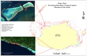
The U.S. Agency for International Development’s (USAID) Pacific-American Climate Fund (PACAM) awarded a grant to The University of Fiji (UoF) to conduct the mapping and monitoring of the reefs surrounding Votua, Ba (Benthic Cover Types at Votua) and Komave, Coral Coast (Benthic Cover Types and Bathymetry at Komave) on the Fijian island of Viti Levu in partnership with the University of South Florida. It is a three year project which started on 15th April, 2015 and will end on 14th April, 2018. The University of Fiji project, Developing Base Maps of Tropical Aquatic Resources in the Pacific, will increase the capacity of the Fijian government and the communities of Votua, Ba and Komave, Coral Coast to protect their coastal and marine resources for the future. USAID’s Pacific-American Climate Fund awarded the grant of US$404,729 to The University of Fiji. The project was launched at an event held at The University of Fiji on April 13, 2015.
Tropical island environments in the Pacific, like Fiji, are suffering significant degradation in water quality, biodiversity, and various other critical parameters. One of the most significant needs is to develop accurate, high-resolution base maps of coastal and shallow-water aquatic resources, including coral and sea grass ecosystems that have significant economic value in terms of fisheries, aquaculture, and tourism, among others. These maps are needed as a baseline against which to measure future changes, and to develop place-based resource management plans.
Such comprehensive maps of marine resources provide crucial information for local fisheries management and biodiversity conservation that will help these communities develop local adaptation strategies to combat climate change and increase their resilience to the impacts.
The Pacific-American Climate Fund used a two step application process for the grant. Firstly, the team comprising staff from Department of Science and Department of Computer Science and Information Technology from The University of Fiji and the team from University of South Florida submitted a brief concept paper, which was evaluated by PACAM experts according to their selection criteria. Secondly, for the approved concept paper, The University of Fiji team was invited to submit full application that included more detailed Technical and Financial Proposals. A Grants Review Committee (GRC) of US Government representatives, PACAM, and/or independent climate change experts, evaluated and ranked the full application against the selection criteria. A Grants Review Board (GRB) comprised USAID and PACAM officials reviewed the outcomes of the Grants Review Committee and made the final recommendation for approval of full applications. Final approval of all awards was made by USAID following completion of pre-award risk assessments. This was carried out to determine UoF’s capacity to manage the funds effectively. The University of Fiji is the only applicant in Fiji, who was successful in the 1st cycle of the PACAM grant application process.
With the USAID support, the University of Fiji is developing maps of land and marine habitat, including the processing of large volumes of regional satellite imagery of island territories, and create a robust data processing system to illustrate the human uses and characteristics of global ecosystems, including coral reefs and wetlands. This information will be disseminated to policymakers and the scientific community and made user-friendly and accessible for other organizations and stakeholders. In addition, the University of Fiji will develop new courses in Geographical Information System and Environment Impact Assessment using the data collected from the two project sites.
The project aims to:
- improve scientific knowledge of the effects of climate change to help develop strategies and policies to protect Fiji’s environment;
- improve understanding of the climate change vulnerabilities of marine ecosystems and resources through a series of high-resolution thematic maps;
- Strengthen curriculum in the Department of Science at The University of Fiji to prepare students to manage, analyze, and display spatial information.
The University of Fiji was established by Arya Pratinidhi Sabha of Fiji to provide high quality, affordable higher education to the many students who had no access to other tertiary institutions. The University’s objectives include providing higher education relevant to Fiji‘s needs, but within a global framework and to support Fiji‘s development as a sustainable, peaceful, inclusive and progressive society committed to good governance. The Ministry of Education and the University have signed an MOU to provide a framework for the relationship between the Government and The University of Fiji until an Act is passed to provide a more complete legislative framework for the University.
The University of Fiji with assistance from USAID is implementing the project, “Developing Base Maps of Tropical Aquatic Resources in the Pacific”. The outlined plan is to map coastal and shallow water marine resources located shallower than 5-10 m depth over large areas in the Fiji Islands. This research will explore the utility of satellite imagery to identify and classify coral reefs, marine benthic habitats and seagrass in Votua (Ba) and Komave (Coral Coast) in Fiji. The program will develop assessments and produce results in a format that is understandable and useful by technical and local stakeholders. This project is expected to enhance University of Fiji’s future research efforts through knowledge and training received by the staff. This expertise can be used to carry out other research projects and environmental impact assessments. The process includes training with experts from the University of South Florida and Secretariat of the South Pacific that have a history of developing local and regional maps based on high-resolution satellite imagery and local expertise from resource users and managers. The program will prepare local experts who would design, use, and market habitat digitization and tracing services using GIS (geographic information system) platforms. The satellite imagery will provide a tool for rapid and accurate assessments that can be compared over time. Although the project will be carried out in Fiji; the capability implemented in Fiji will assist in developing similar maps in the Pacific region.
The maps and associated databases generated during this project will also enable the University of Fiji and other research institutions to carry out more interdisciplinary studies including probable impacts of coral reef geomorphology due to resource use or ocean acidification in response to climate change, changes in biodiversity due to expansion or reduction of habitat of different species as a result of ocean warming, sea level change, or changes in ocean pH and integration with maps and databases from other regions, generated using the same satellites. This enables researchers to monitor and model global changes in ocean related to climate change (e.g. Temperature, pH etc). Additionally these databases will also be beneficial to the local policy decision makers as they will be the important link between such scientific databases and community action plans towards conservation and sustainable management of resources. The local stakeholders including key personnel’s from relevant government ministries and NGO’s will be invited to partake in meetings that seek to understand local problems and identify solutions in partnership. The University of Fiji will be responsible for informing policy makers about accomplishments and recommendations through the project. The local stakeholders will be given access to the thematic maps and databases, however, the project team will work closely with resource managers and policy makers to ensure that the maps are interpreted and used effectively by local communities and researchers.
The University of Fiji’s engagement with stakeholders is expected to fortify and the data provided to them will further assist in setting up of the marine reserves and encourage sustainable use of marine resources which is the livelihood of a lot of local communities in Fiji. Resource maps can be utilized by public policy makers in developing resource management plans to adapt to impacts of climate change, leading to a greater food security and an enhanced livelihood. This project will boost female participation at the University of Fiji and also support female representatives from relevant government ministries and other public sectors to actively contribute towards the decision making process.
Goal
To increase the capacity of the Fijian government and the communities of Votua, Ba and Komave, Coral Coast to develop appropriate climate change adaptation strategies and to make informed decisions related to coastal and marine resource management based on scientific evidence captured through innovative mapping technology.
Objectives
- Build local capacity to develop and use land and submerged habitat classification maps, including processing large volumes of regional satellite imagery of island territories.
- Develop a robust data processing system to produce high resolution, thematic maps that illustrate the human uses and characteristics of global coastal ecosystems, including coral reefs, wetlands, and coastal aquaculture systems.
- Develop a user-friendly interface so that stakeholders can easily access information regarding marine reserves, ecotourism, and sustainable management of marine resources.
- Develop two new courses (Geographical Information System and Environment Impact Assessment) as part of the Environment Science program. Improve several existing courses, already offered by the School of Science and Technology at University of Fiji, for instance: Marine Biology, Natural Resource Management, Aquatic Chemistry, Geography, Ecology, Biodiversity and Conservation, Climate Change and Society.
- Disseminate the thematic maps and data produced during the project to policymakers and the scientific community.

Key Activities
The project team has successfully undertaken few activities in the duration of the project i.e. community engagement, training, symposium etc .For more information, click on “Key Activities“.
Koroinasolo Project
- Unifiji-MV Solar-Fiji-Ltd-to-Supply-Solar-Power-to-Koroinasolo-Village-School
- Solar-Power-for-Rural-School
Seminar:
USAID, University of Fiji Hold Seminar to Improve Management of Fiji’s Coastal Resources
The University of Fiji will increase capacity of the Fijian government and the communities of Votua, Ba and Komave, Coral Coast to develop appropriate climate change adaptation strategies related to coastal and marine resource management based on scientific evidence captured through innovative mapping technology. The University of Fiji will conducted the mapping of two coastal ecosystems: at Cakau Na Sasi Reef and Yarawa Reef (Benthic Cover Types at Votua), Ba, where coral reefs have experienced reduced growth rates, higher mortality due to bleaching, and increased damage by severe weather; and at Cakau Lekaleka Reef, Cakaubalavu Reef, Vatumalawa Reef and Nalumu Reef (Benthic Cover Types and Bathymetry at Komave), Coral Coast, which have healthier fringing reefs attributed to conservation practices.
The resulting maps illustrate relationships between local resources and human activities; show ways in which resources may be affected by climate stress; and serve as a reference by which change may be measured in the future.
This portal provides the unique opportunity for uses to view the maps generated with support from USAID through its Pacific-American Climate Fund (PACAM). These maps have been generated using GIS and satellite imagery which represent high-resolution baseline of coastal marine resources at two coastal communities in Fiji: Votua, Ba and Komave, Coral Coast.
Follow the following link for a guide on using the web mapping application. You will need to download the .zip file and unzip it to access the guide. Open the unzipped file using “Internet Explorer”:
Follow the links below to the web maps for the two project sites:
Follow the link below to static maps of the project sites with their possible applications:
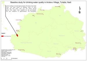
Baseline study for drinking water quality in Arolevu village, Tunalia & Marasa (Nadi)
Name of Principal Researcher: Ms Roselyn Naidu
Research team: Mr. Anish Maharaj
Project Overview
Drinking water quality is a global problem in relation to poor sanitation, industrialization, climate change, agricultural practices and various methods of animal farming. It is therefore important for researchers to determine and analyze the drinking water quality at Arolevu village in Nadi where the major water source for villages are the bore hole and well water which is prone to contamination. Arolevu Village is located 17°S 52′ S and 177° 21′ E.
The research will focus on determining concentrations of metal ions and other mineral ions and fecal coliform counts. The data gathered from this research will be used to create awareness amongst the villages about reducing water contamination and improving their drinking water quality.
Purpose
- To carry out the physical analysis of pH and temperature measurements of water samples.
- Use analytical technique to chemically analyse water samples collected for metal ions, minerals ions and fecal contamination determination.
- Create awareness amongst the community members on ways to reduce water contamination and improve drinking water quality.
Drinking water can consist of organic impurities that occur due to discharges from household and public drains. These contaminations make available energy for microorganisms in drinking water. The microorganisms identified for this study are faecal coliform. The village may have possibilities of fertilizer drainage from farms and sewage leakage which can contribute to the presence of pathogens in the drinking water. The highest level of oxidised nitrogen compound is nitrate. The presence of nitrogen in surface and underwater springs results from nitrogen compounds that are decomposed by bacteria (Aca, N., et al 2014: Bartram and Balance 1996).Chlorine is crucial for water since it efficiently inactivates a high mass of pathogens that if present, can infect organisms. Addition of chlorine to different water system is a common practice but it does not guarantee water safety. Water needs adequate free residual chlorine to be safe for drinking (Farooq, S et al., 2008: Munavali and Mohan Kumar 2003). Activities such as chemical breakdown of rocks and soils, disintegration of dead animal and plant material and human activities like discharge of domestic and industrial waste produce heavy metals that contaminate ground aquifers (Ebrahimzadeh and Boustani 2011).
The study done will be descriptive providing accurate and quantitative data in drinking water analysis. The specific analysis includes:
- Physical analyses, the pH and temperature of the water sample will be recorded.
- Micro-biological analyses, where the concentration of Faecal Coliforms will be analysed. Water sometimes contains organic contaminations, discharged from domestic or municipal drains. These organic pollutants are source of energy for pathogens in water causing the microbiological organisms to thrive.
- Chemical analyses, where the concentrations of Chlorine (residual), Nitrate, Nitrite, Potassium, Calcium, and Magnesium will be determined.
The choice of analyses reflects the guideline provided by World health Organization (WHO) and its Maximum Contaminant Levels (MCLs) on health-based guidelines. The parameters selected for analysis for this study are those that have MCLs. The United States Environment Protection agency (EPA) guidelines to drinking water contaminants were used as reference to determine the sources of contaminants likely to be present at the study site.
Expected Outcomes
- Greater distribution of scientific knowledge that can be applied for community action and improving drinking water quality.
- Better understanding of the climate change vulnerability to drinking water quality through seasonal water analysis.
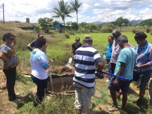
Sample collection sites
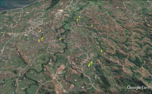
Water Sampling 1 (Dry Season) – 7th October, 2016
The use of GIS in understanding human impacts on Mangrove forests in Viti Levu, Fiji: a time series analysis
Research team: Ms Roselyn Naidu and Mr. Anish Maharaj
Problem statement
Mangrove forests serve as very important ecosystems. They provide vital habitat for fish fingerlings to grow, protect the coastal regions from harmful effects of wave actions and also helps to stabilize land near the coast. Over the past decades due to the pressures from tourism, agriculture and industrial development; chunks of mangrove forests have been reclaimed in the name of development and it continues till this day despite the fact that mangroves in Fiji are of high concern for livelihood and resource management. Due to the surge in computational processing power and the availability of satellite images this study therefore looks at the applications of remote sensing and GIS to map out changes in mangrove distribution over the decades.
Project Background
Mangroves inhabit the intertidal zone maintaining a diverse flora and fauna of marine, freshwater and terrestrial species, stabilizing coastal regions and displaying an important role in primary production (Ellison and Stoddart, 1991). Mangroves in Fiji are comprised of seven main species of trees which can be categorised into three functional groups depending on growth habit: (a) Red mangrove (‘Tiri’) which grows at the water’s edge, with “prop” roots that stabilize trees in soft mud and wave zones. There are two species of trees which live in this manner and one sterile hybrid when both species are present. Red Mangroves consist of: Rhizophora stylosa usually found directly fronting the sea; R. samoensis usually found closer to rivers; and the hybrid R. selela consisting of taller trees found in mixed forest. (b) Black mangrove (‘Dogo’) or Bruguieria gymnorhiza usually found behind red Mangroves in muddy areas that flood at high tide. They may have prop or elbow roots that protrude out of the mud, sometimes both. (c) White mangrove which are very salt-tolerant trees that grow on dry land immediately behind the wet mangrove areas and can survive occasional saltwater inundation and salty soil. The four species consist of: Lumnitzera littorea; Heritiera littoralis; milky mangrove (Excoecaria agallocha); and puzzlenut tree (Xylocarpus granatum). Mangroves are undoubtedly among the most dynamic and biologically elaborate ecosystems on earth. Most prominently, mangroves provide natural adaptation to the effects of climate change. Conservation of mangroves and associated ecosystems has been recognized as an important natural adaptation strategy and mitigation measure to climate change. Protecting these crucial ecosystems also develops the livelihoods of coastal communities. Despite their importance, mangrove vegetation like other marine ecosystems are now being threatened by human-induced processes i.e. climate change, pollution, deforestation, coastal development, sand mining, oil exploration and exploitation (Lal, 2003; Reef and Lovelock, 2014).
Remotely sensed data have been used with GIS in mangrove forest mapping for inventory and monitoring purposes in many parts of the world (Hossain et al., 2007; Kovacs et al., 2008). Landsat TM data could be used to identify the primary mangrove forest, and different succession stages conveniently (Sader et al., 1990, Mausel et al., 1993). Thus, a mangrove vegetation map could be an effective planning tool to show the spatial distribution of mangrove forest in the western Viti Levu. This is useful to build greenbelt as natural fence against natural disasters. Conservation of mangroves is important not only because it is habitat to birds, animals and mirco-organisms but also a natural shelter against floods, tidal waves and cyclones. Therefore, it becomes necessary to map out changes in mangrove distribution over the decades using GIS technology.
Projected Outcomes
- Establish how mangrove cover has changed for Viti Levu, Fiji over the past 30 years
- Disseminate information for better policy decisions
- Strengthen regulations enabling the sustainable management of mangrove resources
Mr Anish Maharaj
Project Manager
University of Fiji, Private Mail Bag, Lautoka, Fiji
Tel: +679 6640600 ext: 266
Fax: +679 6640700
Email: AnishM@unifiji.ac.fj
![]()
